

3D Laser scanning services & As-Buit Surveys
We rebuild the geometry of elements and infrastructures using 3D laser scanner technology
Data collection 3D laser scanner
Laser scanning represents a highly versatile technology with widespread applicability across various industries. Nevertheless, its adoption within the architecture, engineering, and construction (AEC) sector is still in its early stages, and the full spectrum of potential advantages during project execution and for the upkeep and management of existing assets remains underutilized.
The ongoing advancements in 3D laser scanning and the integration with building information modeling (BIM) are ushering in a transformative era within the AEC industry, akin to the advent of computer-aided design (CAD). The 3D laser scanner empowers precise measurements of intricate constructions at any project stage. Integration with BIM substantially enhances quality inspections and project acceptance standards, regardless of the project's current phase.
Distance measurement:
Laser scanning systems primarily record the precise spatial location of a target object, constructing a point cloud composed of points in Cartesian coordinates (XYZ). This is accomplished through the comparison of emitted and returned light pulses, allowing for the determination of the target object's position relative to the scanning instrument.
The scanner computes the object's position by measuring the angle of the scanner assembly, comprised of the scanner head and reflector, along with assessing the travel time of light. This time measurement can be direct, as in the case of flight time scanners, or indirect, as observed in light-based scanners utilizing phase measurements.
Color and intensity:
The laser scanner also records a measure of the return energy (represented as an intensity value) from the surface, which is a function of the characteristics of the target surface and ambient light conditions. Most scanners have the ability to determine the color of each point by using a camera (can be incorporated or separated), which is represented by the scale of values RGB (red, green, blue) commonly used. Because scanners are optical systems, only what the scanner can "see" is captured, so laser scanners can not go through walls or other obstacles (these create "shadows" in the cloud of points where data is not captured) . In fact, the integrity of the data depends on the environmental conditions during the acquisition, as well as the intensity and color data, which vary according to the lighting conditions.
Point clouds:
The measurement data is encoded using a file format that delineates the position, intensity, and color of individual points within the point cloud. Ultimately, this data can be stored in diverse point cloud file formats (e.g., ASCII, PTS, LAS, E57), each employing variations in the XYZ / RGB position, intensity, and color scheme.
Numerous hardware and software providers offer proprietary point cloud formats that can be easily converted to meet the customer's specific requirements. It's advisable for customers to articulate the desired deliverable file formats based on the intended data usage during negotiations with service providers. This becomes especially crucial when integrating the data with pre-existing information management systems.
Customers may find it beneficial to opt for a standard, non-proprietary file format, like the ASTM E57 format for exchanging 3D image data, to ensure alignment with the project's specific needs.
Accuracy of the measurement
Several factors affect the accuracy of the point cloud data, including instrument capabilities and calibration, and quality control measures. Environmental conditions that affect the integrity of the data include the reflectivity of the surface, the angle between the scanner and the target (angle of incidence), and the range to the target object (the laser beam diverges with distance, so the measurements furthest from the instrument are less precise). 3D scanning service providers are experts in controlling these sources of error, so it is crucial to establish functional performance requirements before field acquisition so that the optimal instrument, the scanning position (s) and the Acquisition times can be negotiated with the service provider to achieve the highest quality deliverables. However, a series of general rules that customers must know to ensure the proper development of functional performance requirements are applied.
Mobile / aerial systems:
The mobile and aerial scanning systems, where the scanner is mounted on a moving vehicle during the measurement process, capture additional data about the movement of the vehicle to compensate for the movement. A global navigation satellite system (GNSS) detects the position and speed of the scanner, an inertial measurement unit (IMU) detects the attitude speed and acceleration of the scanner. This information is stored and processed during the data acquisition process, and then the processing. The software generates a point cloud file with the adjusted physical positions, which allows the project teams to capture data very quickly from the physical environment without having that mobilize the team several times. Additional data, such as environmental conditions during the data capture time, as well as calibration and service provider data, may also be linked to the data set. Aerial and mobile scanning is fast becoming the standard method for creating digital city models, documenting road networks, tunnels or power lines, and other infrastructure measurement initiatives.

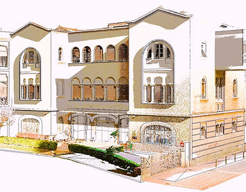


3D laser scanning of buildings in Architecture
Whether dealing with a newly constructed building or an existing one, whether for industrial or civil purposes, employing the 3D laser scanning method stands out as the most straightforward and secure approach to acquire precise construction data, yielding rapid results while maintaining an optimal balance of quality and cost-effectiveness.
The data acquired through the 3D laser scanning process enables a meticulous examination of various aspects of the building, encompassing facades, walls, and more. Remarkably, this analysis can be carried out irrespective of the architectural intricacy or accessibility challenges within the space.
The 3D-scanned information is remarkably precise and invaluable, providing substantial assistance to professionals in the field, including architects, designers, engineers, and builders. Leveraging this data, one can easily execute cost-effective interventions within the building and promptly identify any structural or facade issues that may have emerged over time.
Additionally, the data extracted from the 3D laser scanning of the building remains readily accessible at all times, eliminating the necessity for additional site visits. This accessibility ensures efficient decision-making and comprehensive planning for any future modifications or enhancements to the structure.
Where is the 3D building scanning method applied?
-
New buildings
-
Antique buildings
-
Civil buildings
-
Industrial buildings
Products that can be obtained from 3D laser scanning:
-
Classic Mapping:
-
Architecture plans
-
Blueprints of the floor
-
Level Plans
-
Sections
-
Elevations
-
-
Ortho-images of Facades
-
Horizontal / vertical sections on the facade.
-
3D plant model
-
3D Model / Mesh Model
Use of 3D laser scanning in building analysis:
The utilization of 3D laser scanning in building analysis offers a multitude of advantages and capabilities:
-
Degrade Monitoring and Analysis: 3D laser scanning enables real-time monitoring and in-depth analysis of degradation, inclinations, deformations, and verticality of facades, structures, and building elements.
-
Rapid Degradation Assessment: It allows for a swift assessment of degradation levels across elements, regardless of their surface accessibility, facilitating prompt decision-making and intervention planning.
-
BIM Project Creation: The precise acquisition of 3D data facilitates the creation of detailed Building Information Modeling (BIM) projects, enhancing accuracy and efficiency in the design and construction process.
-
Efficient Project Information Access: The technology ensures quick access to comprehensive project information, including 3D models, plans, and sections, streamlining project coordination and collaboration.
-
Time-Saving Fieldwork: 3D laser scanning significantly reduces the time spent on-site by accurately capturing data during the initial visit, enhancing overall project efficiency and reducing fieldwork duration.
-
Seamless Model Generation: Compatibility with various CAD software allows for the seamless generation of both 3D and 2D models, aiding in design, analysis, and documentation processes.
-
Comprehensive Surface Analysis: It provides a detailed analysis of any contactless area on the surface of the scanned object, aiding in the identification of imperfections and irregularities.
-
Versatile Scanning Range: The technology offers the flexibility to capture data from a wide range of distances, up to 330 meters, even in challenging conditions such as extreme darkness.
-
Progress Evaluation: By scanning in phases, it allows for the real-time evaluation of construction work progress, enabling timely adjustments and ensuring project timelines are met.
-
Precise Before-and-After Comparisons: Accurate comparisons of the building before and after modifications or rehabilitations are possible, providing valuable insights into the impact of the changes and ensuring quality control.


